
Utility mapping in Menifee gives civil engineers, developers, and contractors a clearer picture of buried infrastructure before grading, excavation, or roadwork begins. On fast-growing sites where new improvements must fit around existing utilities, field markings alone may not provide enough detail. At Superior Scanning, subsurface information can be collected and organized into usable mapping that supports design, coordination, and construction planning.
Why Menifee's Growth Makes Underground Coordination More Complex
Rapid development creates an unusual problem: new infrastructure often has to coexist with utilities installed during several earlier phases of construction.
Menifee continues to add residential communities, commercial centers, roadway improvements, and public infrastructure across areas that may already contain water, power, sewer, communications, irrigation, and storm drainage systems.
Some utilities may be well documented.
Others may have been relocated, extended, abandoned, or installed differently from the original plans.
That difference becomes significant during Riverside County site grading, where several feet of soil may be removed, filled, compacted, or reshaped across a large project area.
At Superior Scanning, utility mapping is used to turn field findings into information that project teams can compare against proposed grading, foundations, drainage, and utility designs.
Field Paint Is Useful, but Engineering Teams Often Need More
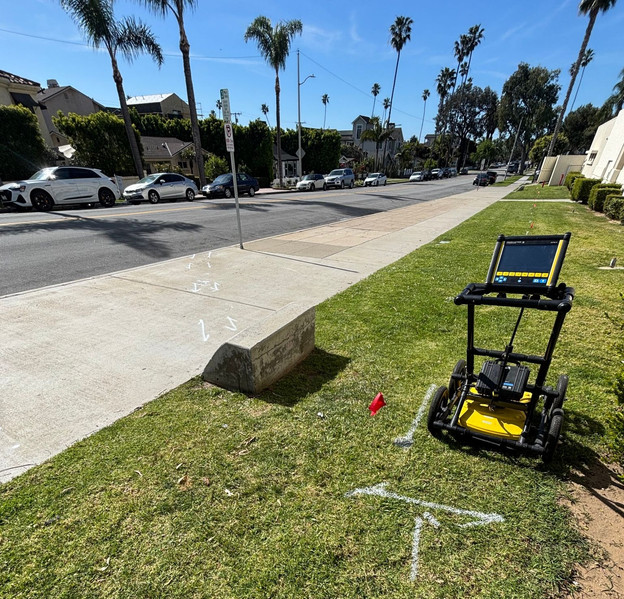
Paint and flags are effective for showing a utility location in the field.
They have limits once the project moves back into the design office.
A civil engineer may need to know how the detected line relates to a future curb, retaining wall, storm drain, building pad, or proposed utility corridor. A project manager may need to compare dozens of buried features across several acres.
That is where subsurface utility mapping in Menifee becomes more useful than isolated markings.
Mapped utility information can be incorporated into drawings so different disciplines are looking at the same subsurface conditions instead of relying on memory, field photographs, or disconnected notes.
What Does Subsurface Utility Engineering Add to the Process?
Subsurface Utility Engineering, commonly called SUE, is a structured approach to identifying, documenting, and managing existing utility information for design and construction.
The process may include records research, visual site investigation, geophysical locating, surveying, and physical verification depending on the level of certainty required.
At Superior Scanning, subsurface utility engineering in Menifee can support projects where utility information needs to become part of a broader engineering workflow.
Not every detected line automatically carries the same level of certainty.
A utility shown on an old record drawing is different from a utility located in the field. A physically exposed pipe provides another level of confirmation.
Understanding that distinction helps engineers decide how much confidence to place in each mapped feature.
Why Utility Depth and Horizontal Position Matter During Site Grading
A utility can be nowhere near a proposed foundation and still create a conflict.
Grading changes elevations.
A line that currently has several feet of cover may become too shallow after excavation. A proposed fill area can create different access or loading conditions. New retaining walls and drainage structures may also cross utility corridors that looked acceptable on an early conceptual plan.
The most useful utility map shows how buried infrastructure relates to the planned work, not simply where the line appears on the existing ground surface.
This becomes particularly important on large Menifee developments where several design packages may overlap.
At Superior Scanning, underground findings can provide another layer of information for teams evaluating grading limits, trench routes, and proposed improvements.
How Does 3D Subsurface Utility Clearance Help?
3D subsurface utility clearance allows utility information to be evaluated in horizontal and vertical space so designers can see where proposed improvements may conflict with existing infrastructure.
A conventional plan view mainly shows where objects sit from above.
Three-dimensional information can add elevation or depth data where those values are available and properly established. That makes the information more useful when proposed utilities cross existing lines at different elevations.
For example, two utilities may appear to intersect in a two-dimensional drawing.
They may actually pass safely above and below each other.
The opposite can also happen. Two lines that appear separated on a plan may become a problem because a proposed excavation slope, footing, or structure extends into the utility's space.
This is where civil engineering clash detection becomes valuable.
What Is a Utility Clash?
A utility clash occurs when an existing buried feature occupies the same space, or an unsafe construction zone, as a proposed improvement.
The conflict does not always involve two pipes physically touching.
A proposed storm drain may require a trench wide enough to affect a nearby electrical duct bank. A retaining wall footing may extend into an existing water service corridor. A new sewer may technically pass below another utility but leave insufficient vertical separation.
Common clashes can involve:
-
Proposed water lines crossing existing electrical systems
-
Storm drains conflicting with sewer laterals
-
Retaining wall footings near utility corridors
-
Building pads over buried infrastructure
-
Road widening through existing communications routes
-
Grading that reduces utility cover
-
New dry utilities crossing older wet utilities
Finding these problems during design gives the project team more choices.
Finding them after excavation begins usually gives fewer.
From Field Detection to CAD: Where the Mapping Becomes Useful
At Superior Scanning, the field investigation is only one part of the process.
The value increases when detected utility information can be organized in a format that designers and engineers can actually use.
Depending on the project scope, mapped information may include:
|
Mapping Element |
How It Supports the Project |
|
Horizontal utility alignment |
Shows where detected lines cross proposed improvements |
|
Utility type or classification |
Helps separate water, electrical, communications, and other systems |
|
Surface features |
Connects valves, vaults, meters, poles, and access points to buried routes |
|
Depth information where available |
Supports vertical clearance and grading review |
|
CAD-compatible data |
Allows findings to be incorporated into engineering drawings |
|
Field notes |
Provides context for ambiguous or difficult-to-trace features |
For large developments, keeping this information organized is important because multiple teams may use it at different stages.
A civil engineer may use the data during design.
The grading contractor may refer to the same information later during construction.
Can Utility Mapping Replace Potholing?
No. Utility mapping can significantly improve subsurface understanding, but physical exposure may still be required when exact utility depth, size, or position is critical to design.
Potholing, also called daylighting, exposes a utility at a specific location so the line can be directly observed and measured.
Geophysical locating provides valuable non-destructive information, but some design decisions require a higher degree of confirmation.
This is especially true around critical crossings.
At Superior Scanning, mapping and physical verification can serve different purposes within the same project. The map helps narrow the problem. Verification can then focus on the locations where precise information matters most.
Why Old Utility Plans Should Not Be Treated as Final Field Conditions
Record drawings are useful starting points.
They are not always perfect representations of what is underground today.
Construction changes happen. Field crews may adjust routes to avoid an unexpected obstruction. Later expansions may add lines that never make it onto the original record set. Some utilities may also be abandoned while remaining physically in the ground.
That is why underground utility mapping in Menifee often includes comparing available records against current field observations.
When the two disagree, the discrepancy itself becomes valuable information.
When Should Utility Mapping Happen?
Utility mapping provides the most value before final grading and utility designs are locked, while engineers still have room to change alignments.
A practical sequence can look like this:
-
Gather available utility and civil records.
-
Review proposed grading and site improvements.
-
Identify areas where utility conflicts are most likely.
-
Perform geophysical utility locating.
-
Survey or document detected features as required.
-
Build the utility information into the project mapping.
-
Compare existing utilities against proposed work.
-
Physically verify critical conflicts where needed.
-
Revise design elements before heavy excavation begins.
This sequence places utility information upstream of construction rather than treating it as a last-minute excavation check.
What Should Engineers Provide Before Utility Mapping Starts?
A current site plan and proposed work limits provide the strongest starting point because they show exactly what the subsurface investigation needs to support.
Available as-built drawings, utility records, grading plans, and known connection points can also help define the scope.
At Superior Scanning, project context matters.
A utility investigation for a small commercial addition is different from mapping a multi-acre development with road improvements and new utility corridors. Understanding the end use of the data helps determine how much of the site should be investigated and how the results should be organized.
Utility Mapping Turns Unknowns Into Design Information
Fast-growing cities such as Menifee create constant interaction between existing infrastructure and new construction.
The challenge is not simply finding buried utilities. It is getting that information into the hands of the engineers and contractors making design and excavation decisions.
At Superior Scanning, utility mapping in Menifee helps connect field-detected infrastructure with grading plans, proposed utility routes, and other civil design elements. With better subsurface information available earlier, project teams can identify potential clashes, prioritize verification, and revise plans before heavy equipment reaches the conflict.