
Over the course of the last few years Gilba Solutions has been looking at the use of remote sensing of sports grounds to determine wear and overall turf health. Historically this has been done using hand held or towed mobile units which involve physically passing over the surface to be monitored. This can be extremely time consuming.
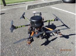
Recently we have been looking at utilising UAV (Unmanned Aerial Vehicle) technology or drones to carry out this work. This offers a number of advantages:
· Extremely quick
· Gives an overview of the entire area down to 2cm resolution
· Depending on the sensor used it can determine for example wear patterns or potential issues such as soil contamination .
Remote sensing has been used in agriculture for years and is widely accepted as an ideal platform to monitor crop health, identify disease or irrigation issues thus better focusing your dollar where it is needed most.
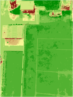
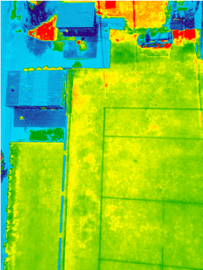
The following is an example of work carried out recently in Sydney looking at turf health using drone imagery. NDVI (Normalized Difference Vegetation Index) is a method of taking the information in pictures and quantifying the amounts of infrared and other wavelengths of light reflected from vegetation. This can be used to evaluate health of vegetation by comparing ratios of blue and red light absorbed versus green and IR light reflected. It's a snapshot of how much photosynthesis is happening. This is helpful in assessing vegetative health or stress.
Combine this with the latest drone technology, sensor technology and their overall versatility and you have a complete aerial imaging solution offering real time imagery and unprecedented accuracy.
· Give your committee a bird’s eye view of any works you are carrying out or that are proposed
· Site redevelopment can be planned with ease and efficiency
· Identify agronomic issues before they develop.
· Produce stunning images for your website or promotional literature.
To the naked eye often issues are not that easy to identify. By taking to the air this gives us a means of rapidly getting an overview of any issues and being able to act accordingly. The beauty of this system is shown below where both handheld and airborne NDVI analysis was taken of a site in Sydney.
The image opposite shows the area of concern and following on from this are comparative NDVI analysis. Image 1 is the handheld standard and it can be seen that there are issues evident at the northern end where turf is struggling.
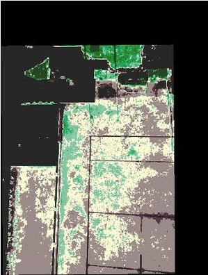
This is only part of the story however. Interpreting these images is where Gilba Solutions come in. By using experience gained from over 8 years remote sensing work coupled with proprietary software we can interpret these images and identify areas of concern. These images confirmed the following which was supported by soil testing:
1. Soil contamination at the northern end of the site
2. Turf struggling as a result of this
3. The oversowing programme was had gone some way to protecting the underlying turf surface.
The result of this work was that we were successfully able to help our client identify these issues and develop a management plan as a result of the soil contamination.